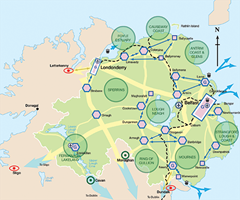
Regional Development Strategy: local impact
 The new council will benefit from its existing strong infrastructure but will need to balance the needs of Craigavon with its neighbours.
Armagh, Banbridge and Craigavon’s shape is reflected in the clustering of the three settlements set out in the Regional Development Strategy, the province’s blueprint for planning up to 2035. The strategy makes clear that this is not a rigid framework and emphasises that there is “nothing to prevent other towns working together in clusters and indeed this should be encouraged.”
For example, Armagh is free to develop links with Dungannon, Newry and Monaghan, along the ‘link corridors’ of the A29, A28 and A3 respectively. Monaghan is a hub in the Republic’s National Spatial Strategy and the nearby border area would benefit from joined-up spatial planning between the two jurisdictions.
Craigavon was Northern Ireland’s most ambitious experiment in central planning. The project did not reach its full potential but nearly 50 years on, its infrastructure still strongly influences the Regional Development Strategy.
This will be the only new district where the three main towns are also ‘main hubs’. It also sits between three ‘strategic natural resources’ (i.e. Lough Neagh, the Ring of Gullion and the Mourne Mountains) which offer some of Northern Ireland’s best potential for leisure and tourism.
Hub settlements “should not compete for scarce resources” and therefore should co-operate where they are geographically close to each other.
Transport writer Wesley Johnston recalls that the original M1 planners had intended a single junction for Lurgan and Portadown but relented under local pressure and built one for each town. The M12, envisaged as Craigavon’s urban motorway, was only partially completed.
Within the Craigavon urban area, Lurgan contains Northern Ireland’s largest urban park and stands to benefit from its proximity to the Oxford Island nature reserve and Lough Neagh. Portadown has the potential for a “rediscovered and rejuvenated” riverside area.
More than half (53.7 per cent) of all the projected council’s residents live in Armagh and Banbridge.
Armagh is recognised for its “unique sense of place in Ireland”, including its status as its “spiritual capital” since 445AD. Making the best use of its strong tourism offering (including two cathedrals, museums, the planetarium and Navan Fort) depends on improving the city’s strategic transport links.
Banbridge has a good quality natural and built environment and a “robust” telecommunications infrastructure. It will “continue to have a key role” as an important retail and commercial centre in the ABC cluster. The A1 runs past Banbridge and Dromore but local traders are concerned that shoppers will increasingly pass both towns by, in favour of The Outlet or Sprucefield.
Over the 2008 to 2025 period, the strategy predicts that Craigavon will require another 10,300 households with an extra 5,500 each in Armagh and Banbridge: a total of 21,300.
Between 2008 and 2011, the number of occupied housing units increased by 2,557 in Craigavon, 1,029 in Armagh and 935 in Banbridge, totalling 4,521 across the area.
There is a potential conflict in the strategy between growing the population in its hubs and sustaining rural communities. Half of Banbridge district lies beyond the A1 and the ABC district’s furthest points are 20 miles from the expected headquarters in Craigavon. Priorities include revitalising small towns and villages, improving rural transport for the elderly and disabled, and using the community hall, local school or church hall for providing public services.


