From two boroughs to one
 A preview of the area’s population and politics.
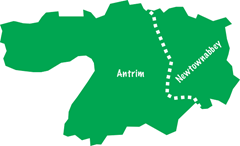
Antrim and Newtownabbey takes in a long strip of countryside but half of its population will be concentrated around Glengormley and Carnmoney, on the edge of Belfast. This urban core is split three ways between the South Antrim, North Belfast and East Antrim parliamentary constituencies. The rest of the new council area falls within South Antrim.
In the 2011 census, the entire area had 138,567 residents, of whom 85,139 lived in Newtownabbey (61 per cent) and 53,428 in Antrim (39 per cent).
Across Antrim and Newtownabbey, the 2011 local government election resulted in a 39 per cent share for the DUP, followed by 20 per cent for the UUP. When minor unionist parties were added, the unionist poll reached 61 per cent.
Nationalist candidates gained 23 per cent of the vote i.e. 13 per cent for Sinn Féin and 10 per cent for the SDLP. The Alliance Party received 14 per cent. Turnout was low in both council areas: 50 per cent in Antrim and 49 per cent in Newtownabbey.
In terms of community background, Antrim and Newtownabbey is 61 per cent Protestant and 30 per cent Catholic with 9 per cent from another background or none. The Catholic minority is larger in Antrim than in Newtownabbey: 41 per cent compared to 23 per cent.
Together, the two existing councils have 44 councillors, which will mean only a small reduction to the new total (40). Under the super-councils plan, Antrim and Newtownabbey would have formed the core of the proposed Inner East council, alongside Lisburn and Carrickfergus.
Most parties accepted the name of the council. The UUP, though, had proposed ‘Six Mile Valley Council’ as the feature cut across both areas.
The unionist parties had called for Rathcoole and the surrounding areas to be moved into Belfast, which would have increased the city’s Protestant population. The boundary commissioners turned down the proposal as it was “based primarily on matters of community identity and local ties” and therefore fell outside their remit.
Newtownabbey was content with the boundaries while Antrim wanted to add Kells (from the Ballymena borough) and the Lough Neagh shoreline which fell within Lisburn’s area.
This proposal was also unsuccessful. However, the commissioners placed the Belfast High School estate in Antrim and Newtownabbey, as it would have been split between the new district and Mid and East Antrim.
Before the formation of the current councils in 1973, Antrim and Newtownabbey had smaller districts of their own. The surrounding area belonged to the Ballyclare, Ballymena and Larne rural districts.
The current councils were both granted borough status in 1977. Once established, the new council will be able to choose whether to become a new borough. Due to the status quo, it is likely to be named Antrim and Newtownabbey Borough Council.
The location of the headquarters has not yet been decided.


